SCOPE › Detect forest clearing from space
Detect forest clearing from space
Forests change every season, which is why naive change detection produces constant false alarms. SCOPE compares the same calendar window in earlier years before calling anything unusual, so what it reports is clearing rather than autumn.
A real example
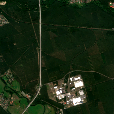
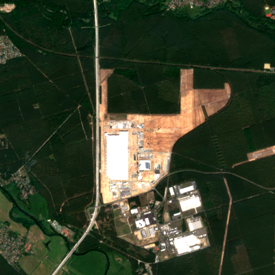
Tesla Gigafactory, Grünheide, Germany
Between summer 2019 and summer 2021, SCOPE measured 262 hectares of pine forest cleared for the factory — with the change dated to the window in which it happened.
Who uses this
How SCOPE measures it
- Sentinel-2 optical imagery at 10 m. Every usable image in each period is cloud-masked and combined, so one bad day cannot create a false result.
- Sentinel-1 radar as an independent check. Radar is unaffected by cloud, so a change confirmed by both sensors is far more trustworthy than one seen in a single optical image.
- The same season in earlier years. Before anything is called unusual, SCOPE checks what that place normally does at that time of year.
- A confidence and a date bracket per area, plus a PDF, GeoJSON and CSV you can take to a surveyor, an insurer or a court.
What it will not do
SCOPE measures change; it does not confirm who caused it. Areas under a hectare are below what 10 m pixels can resolve. Persistent cloud limits the optical view, and the report says when that happened rather than hiding it. On its own published benchmark it found the change at 39 of 41 recorded events, raised no false alarms across 27 desert and undisturbed-forest control sites, and did flag change at city-centre controls — because cities genuinely change.
Questions
How small a clearing can be detected?
Roughly a hectare. Below that, 10 m pixels cannot separate real clearing from noise.
How do you avoid flagging normal seasonal change?
Every candidate area is compared against the same months in previous years. If the change looks like what that place does every year, it is reported as seasonal, not as an alert.
Is the imagery free to use commercially?
Yes. Copernicus Sentinel data is open and free for commercial use, with attribution to ESA.
Try it on a place you already know
If SCOPE is right about somewhere you know well, you can trust it somewhere you do not. 5 scans a day, free, no card.